Introduction
The Southern Upland Way is Scotland's official Coast to Coast Trail from Portpatrick in Dumfries and Galloway on the west coast, through the Scottish Borders, to Cockburnpath in Berwickshire near the east coast. It was 218 miles long and took 15 days in two parts - 12 days in April and 3 days in September 2023. This blog post covers the section from Beattock near Moffat to the end at Cockburnspath on the east coast south of Dunbar.
Mostly I walked it on my own with my wife Jan dropping me off in the morning and picking me up in the evening. Some days Jan walked with me in the morning for a few miles then turned back to the car so that she could pick me up later. The official website is run by Dumfries and Galloway Council.
I'm a professional photographer and darkroom printer working exclusively in black and white using traditional film as well as traditional printing methods.
I decided not to carry my heavy camera equipment for this trip as I also have a chronic back condition. Just using a small, light digital camera was the compromise I decided upon, hence all the colour photos in this post.
I also took Naproxen every day after breakfast because I've found over the years that taking it before the pain starts reduces the pain or stops it completely. Taking it after the pain has built up does nothing.
Day 10 Monday 24th April 2023
Beattock to Ettrick Village 13.5 miles 6.8h
Jan drove us back to yesterday's finish point and parked the car as she was walking with me for the first few miles today. It was bright and sunny but cool.
We started walking at 10am along the wide gravel track next to the bridge and Water of Moffat which quickly narrowed to single track. Forestry lorries were frequently using it as we walked along.

Starting point bridge over Moffat Water near Craigbeck 10.05am

Diversion to the High Route 10.30pm
I was intending to use the low route today as I was a bit tired but there was a diversion over the High Route because of forestry operations. So, in view of the signs and lots of lorries we diverted up the hill.

Cornal Burn at the foot of the High Route 10.40am
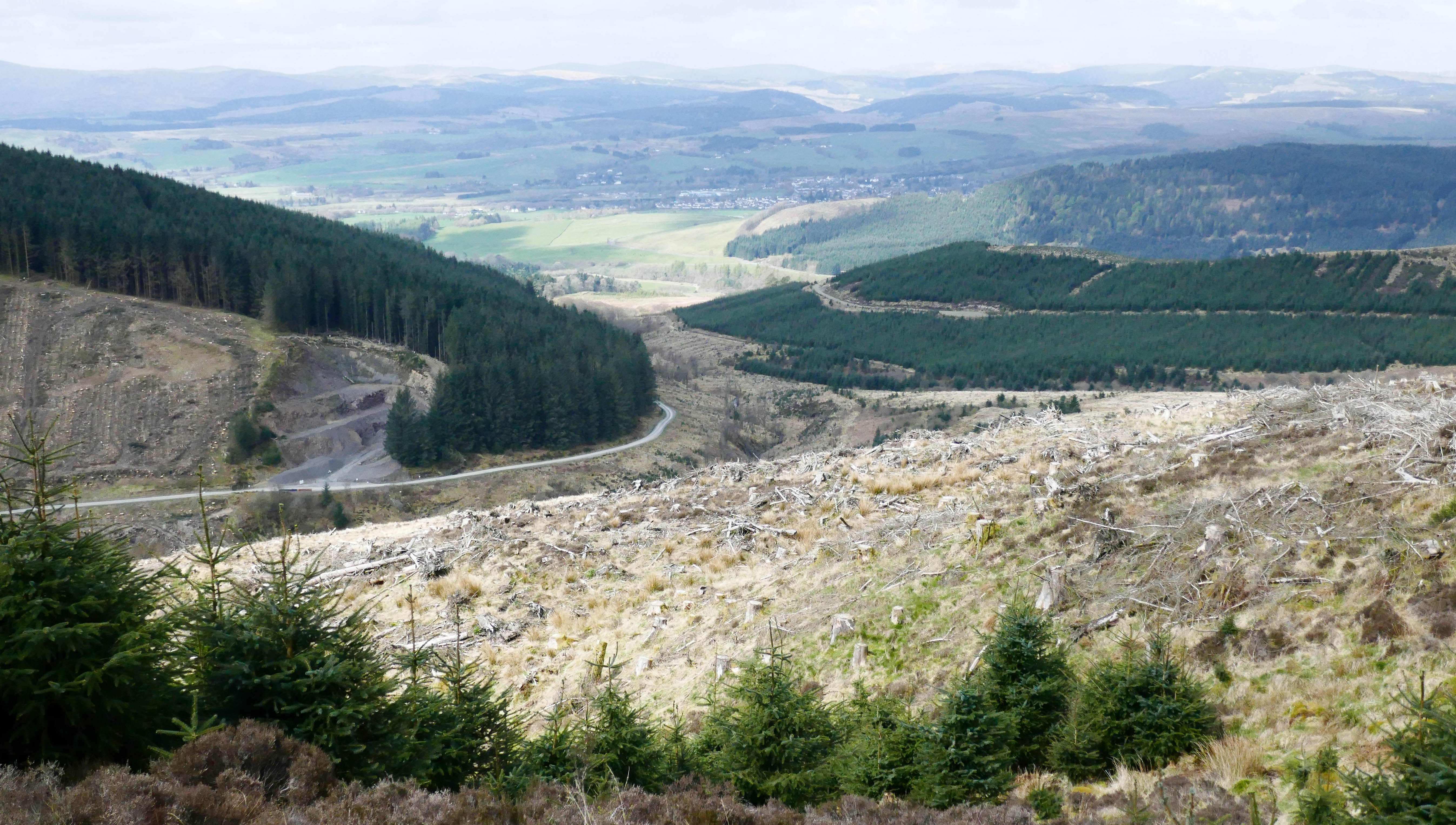
View from part-way up Gateshaw Rig looking back to Moffat 11.20am

Golden Eagle sign - we didn't see any!

Gateshaw Rig View 11.55am
Jan turned back at Gateshaw Rig at 11.50am 3.3 miles, the weather had changed and hail showers started in between sunny spells. I put full waterproofs on before continuing along the ridge. Fortunately, most of the showers passed in about 20 minutes.

Gateshaw Rig View 11.55am

Gateshaw Rig View 11.55am
I carried on along the ridge on a decent track to Croft Head 637m which I reached at 12.25pm and just over 4 miles from the car. There were pretty impressive views all around to the neighbouring hills.

Croft Head View 12.35pm

Descent from Croft Head down Cat Shoulder, Capel Fell on left 12.40pm

Descent from Croft Head down Cat Shoulder 12.45pm

View from Cat Shoulder Northwest 12.45pm

View South to forest storm damage from Cat Shoulder 12.45pm

Sheepfold at foot of Cat Shoulder, notice bench seat on left 12.55pm
At 1pm 4.7 miles I stopped for lunch at a conveniently placed bench seat at the foot of Cat Shoulder. Even though I was looking up at quite big peaks there were still good views.

Looking back up Cat Shoulder to Croft Head from my lunch bench seat

Craigmichen Scar from lunch stop 1pm

Croft Head and Cat Shoulder from near Footbridge 1.25pm

Ultreia Post near Ettrick Head - Spot the Kist!
Kist 8
At 1.30pm 5.1 miles I passed an Ultreia post and dropped down to a footbridge over a stream. It didn't take long to spot a very strange looking cairn which I headed for. The Kist was next to it set into the ground.

Footbridge after Ultreia post

Kist, Cairn Artwork and Footbridge

Kist 8 and Waymerks

Croft Head, Cat Shoulder and Footbridge

Leaving Dumfries and Galloway into Scottish Borders in snow storm 1.55pm

Signpost opposite Over Phawhope Bothy - Beattock 10.5 miles - St Mary's Loch 10.5 miles 2.35pm
At 2.35pm 7.5 miles I reached the Over Phawhope Bothy and a signpost showing the same distance to both back to Beattock and on to St Mary's Loch - 10.5 miles.

Over Phawhope Bothy near Ettrick 2.35pm

Over Phawhope Bothy near Ettrick 2.35pm

Potburn near Ettrick 2.50pm

Scabcleuch 4.45pm
I reached the planned days end of Scabcleuch at 4.45pm 13.5 miles. There was no sign of Jan and the car as I was quite a bit earlier than I'd estimated. After sitting on the bridge wall for a few minutes I decided I may as well do something so walked along the road into Ettrick village and waited in the phone box outside the village hall as there were more hail and rain showers. Jan arrived at 5.30pm.
I walked 14.7 miles in just over 7 hours with 4100 feet (1250 metres) ascent over Croft Head.
Day 11 Tuesday 25th April 2023
Scabcleuch to Traquair 17.2 miles 8.1h
It was a sunny morning but only 3°C at Scabcleuch, near Ettrick village, as we parked the car in a long lay-by just before the road went over the bridge. Jan was walking with me for the first few miles as we set off uphill at 9.50am.

Scabcleuch 9.50am

Path from Scabcleuch to St Mary's Loch 10.30am

Peniestone Knowe Footpath Junction 10.45am 1.6 miles

Pikestone Rig Path 11.05am

Pikestone Rig View ahead to The Wiss - 11.20am Jan turned back here

Pikestone Rig Descent 11.30am

Riskinhope Hope 11.35am

Riskinhope Hope 11.35am
This gate is just above the stream at the foot of the descent from Pikestone Rig. It slopes towards those coming from the uphill side so it's heavy and awkward to push open. Not great for someone with a bad back!

Riskinhope Hope Footbridge over Burn 11.45am

First View of St Mary's Loch - Just! 12.15pm

St Mary's Loch and Tibbie Shiels from Above 12.25pm

Southern Upland Way Information at Tibbie Shiels 12.35pm 5.2 miles

Loch of the Lowes from Tibbie Shiels 12.35pm

St Mary's Loch from Yacht Club Clubhouse near Tibbie Shiels 12.45pm

St Mary's Loch from Yacht Club Lunch Stop at Tibbie Shiels 12.45pm
I stopped just past the clubhouse of the yacht club for a bite to eat, it was sunny and cold so I didn't stop for long. There wasn't much activity as most of the boats were out of the water and all stored together in an enclosure, still in their winter wrappings.

St Mary's Loch 1.20pm

St Mary's Loch 2pm 8.2 miles
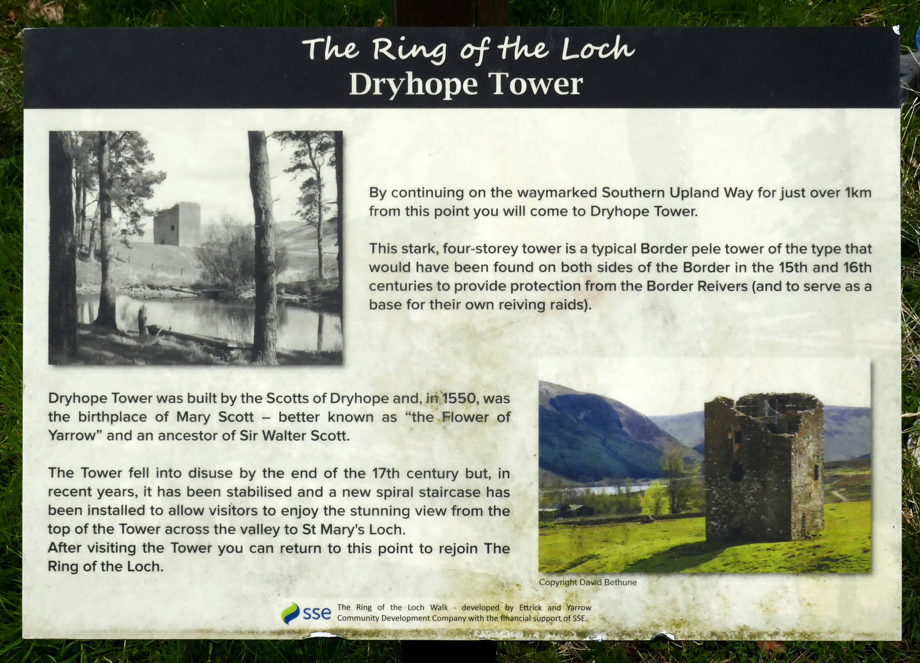
Dryhope Tower Information

Dryhope Tower near St Mary's Loch 2.35pm


Dryhope Tower and St Mary's Loch 2.35pm
I passed Dryhope Tower at 2.35pm but didn't divert for a look around as it was a long day and I was barely half-way.

South Hawkshaw Rig View Ahead 2.55pm

Footbridge over Hawkshaw Cleuch before Craighope and Blackhouse Tower 3.10pm

Brakehope Rig Forest Lunch Stop 2 - 4pm 12 miles

Deuchar Law View 4.15pm

Deuchar Law View 4.20pm

Deuchar Law View to Blake Muir
Kist 9
Kist 9 looks like a milestone and has the word Ultreia and some patterns carved into it. As far as I could tell there were no Ultreia wooden posts as there are for other kists. I missed Kist 9 the first time as it had been ripped from its concrete and reinforced steel fixing and was laying on its side. It looked like it had been vandalised as it is heavy and was a few feet from the original base. Either that or there's horrendous weather on Deuchar Law!
I have a bad back so can't do any heavy lifting but my wife flexed her muscles and managed to stand it upright again but it was too heavy to move back onto its base. At least it was visible from the track when we left it.
Kist 9 was just over 3 miles from Traquair Kirk so maybe it should have been called the Traquair Kist instead of Yarrow Kist?

SUW post on Deuchar Law spur and Ultreia Kist in background

Ultreia Kist knocked down on its side

Waymerks were in a plastic bag inside the Kist

Kist Standing Upright Again

View from Deuchar Law to Blake Muir 4.30pm
This view was taken between Kinchie Cleuch Burn and Sprain Burn - interesting patterns on the Blake Muir hillside.

Gate and Stile between Deuchar Law and Blake Muir near Sprain Burn 4.40pm 14 miles

Innerleithen from Blake Muir 4.50pm

Road to Traquair and Innerleithen 5.35pm

Traquair Kirk 5.40pm

Traquair War Memorial - Days-End 5.50pm
Well that was a good day but a long one. The tracks were all very good and it was easy to follow the route even without a GPS! It stayed clear and cold all day. I had mild backache for the last section from St Mary's Loch but it soon recovered after a lie down on a hot pad in our hotel room.
In total it was 17.2 miles in 8 hours with 4000 feet (1220 metres) ascent.
My average moving speed was 2.8mph but I had a few breaks too which brings the overall speed down a bit.
Day 12 Wednesday 26th April 2023
Traquair to Galashiels 14.2 miles 6.8h
We were staying at the Traquair Arms in Innerleithen so it was just a 5 minute drive to the start of the walk at Traquair War Memorial. Jan dropped me off and I started walking at 9.15am. There were sunny spells through the day but it was chilly.

Innerleithen from Cross Borders Drove Road near Traquair 9.35am

Animal Memorials beside track above Traquair 9.50am

Minch Moor Point of Resolution Landscape Sculpture 10.25am


Cheese Well 10.30am

Cheese Well

Minch Moor Signpost

Minch Moor Summit 10.50am

Minch Moor Signpost with Ultreia Plate 1
Kist 10
Kist 10 is on the track over Minch Moor after the Cheese Well. It's built into the remains of a dry stone wall beside the track. The Waymerks were protected in a metal tin inside a ceramic container with a small slab of rock closure.

Kist 10 in dry stone wall remains

Kist 10 opened

Minch Moor Ultreia Post 2

Looking Back to Minch Moor and Hare Law 11.35pm
I have a bad back and it wasn't that good today after several days of coughing and the long day yesterday. It was aching by the time I reached Brown Knowe at 11.45am 5 miles, just after taking this photo. I stopped to take Diazepam as I was afraid my back muscles would go into spasm. I'd already taken Naproxen after breakfast so it was belt and braces time!

View from Lucken Head 12.35pm

4 Lords Lands Signpost Above Yarrowford 12.45pm

View from near Broomy Law Above Yarrowford 12.50pm 7.3 miles
This was the view from my lunch stop which was just after Broomy Law.

3 Brethren and Trig Point 1.20pm 8 miles

3 Brethren and the 3 Eildon Hills in background 1.20pm 8 miles

Near 3 Brethren 1.35pm 8 miles

Red Score Nick Path 1.55pm

River Rescue Practice by Emergency Services in River Tweed at Yair 2.25pm 10.5 miles

Galashiels from Hog Hill 3.15pm

Galashiels Paths sign replacing SUW signs

A well earned pint in Wetherspoons at the end of the day!
It was a total of 14.2 miles with 3100 feet ascent and took 6h 48m from Traquair War Memorial to the Wetherspoons in Galashiels. Jan was waiting for me just outside as I'd kept in touch through the day with my progress.
My back held up to the end of the day, thankfully, but waking up coughing during the night put some of my back muscles into spasm, as I'd feared on the hill. It was telling me it was time to stop so we went home with 3 days left. Disappointing but necessary for recovery, coughing, asthma and bad backs don't go well together - I was lucky to be able to walk for 7 days with a chest infection.
Day 13 Monday 25th September 2023
Galashiels to Lauder 13.5 miles 5.4h
5 months after having to stop walking the Southern Upland Way because of my bad back my wife and I came back so that I could walk the last 3 days from Galashiels to Cockburnspath.
We parked on Scott Street in Galashiels and I started walking at 9.45am and it was sunny.

Galashiels Scott Street 9.45am

Galashiels from Gala Hill 10.05am

Galashiels from Gala Hill 10.05am

River Tweed near Melrose and Eildon Hills 11.15am

Sheep having a lie-in Beside River Tweed 11.15am

Gattonside Track near Melrose 11.20am

Malcolms Rode or Roman Dere Street near Gattonside 11.25am

Easter Housebyres near Melrose 11.55am

View from my Lunch stop - a Homemade Eccles Cake 12.10pm

SUW Signpost 12.20pm

Malcolms Rode or Roman Dere Street 12.25pm

Malcolms Rode or Roman Dere Street 12.30pm

Bluecairn 1.20pm

Bluecairn 1.20pm

Jeaniefield 1.25pm

Jeaniefield 1.25pm

Jeaniefield 1.35pm

Jeaniefield 1.35pm
Kist 11
Kist 11 is right beside the track but is easy to miss as it blends in with the surroundings. It's a life-size ceramic pair of Roman feet. The top ceramic plate is broken so is held down with rocks. It's just 3 miles from Lauder so it's quite a bit closer to Lauder than to Melrose.

Arriving at Kist 11

Kist 11

Kist 11

Kist 11 - Looking Back

Ultreia Post after Kist 11 1.55pm

Warning Notice on Trail 2pm

Trail Avoiding Motor Racing Area - Fordswell Woodheads Hill 2.10pm

Fordswell Woodheads Hill - Road into Motor Racing Area 2.15pm

Chester Hill near Lauder 2.45pm

Lauder from Chester Hill 2.50pm

Lauder from Chester Hill 2.55pm


Lauder Kirk and Graveyard 3.05pm

Lauder Market Place and Old Town Hall 3.10pm
In total it was 13.5 miles with 1575 feet (480 metres) ascent and I took 5h 25m. A reasonably easy day along good tracks and minor roads - and good weather all day.
Day 14 Tuesday 26th September 2023
Lauder to Longformacus 16.1 miles 6.4h
We parked the car just off the Market Square in Lauder and, at 9.25am, Jan and I started walking through the grounds of Thirlestane Castle on well laid, marked and fenced paths. It was dull, dry and windy.

Lauder 9.25am

Lauder Thirlestane Castle 9.45am

Lauder Wanton Walls 10.05am
Jan turned back at 10.30am on Park Hill above Wanton Wall. I headed off, past a small pond and what looked like a nature reserve at the foot of the hill, towards Edgarhope Moor.

Edgarhope Moor SUW post 11.05am

Edgarhope Moor Blythe Water 11.15am

Edgarhope Moor Blythe Water Footbridge 11.20am
I stopped for a bite to eat at the bridge - it made for a very convenient seat- just an Eccles Cake and a small chocolate bar.

Braidshawrig Farm 12pm

Braidshawrig Farm 12.10pm

Braidshawrig Farm 12.10pm 6.3 miles

View to Twin Law 1.10pm
Kist 12
Kist 12 is another one that is right beside the track and is very difficult to miss.

View to Twin Law and Kist 12

Kist 12

Kist 12

Ultreia Post After Kist 12

Twin Law Summit 1.35pm

Twin Law Summit 1.40pm

Twin Law Summit 1.40pm

Watch Water Reservoir from Twin Law Summit 1.40pm
Just after taking this shot the rain started so it was on with my waterproofs for the rest of the day. It was quite heavy on the tops but light showers lower down.

Watch Water Reservoir from near Scarlow 2.40pm
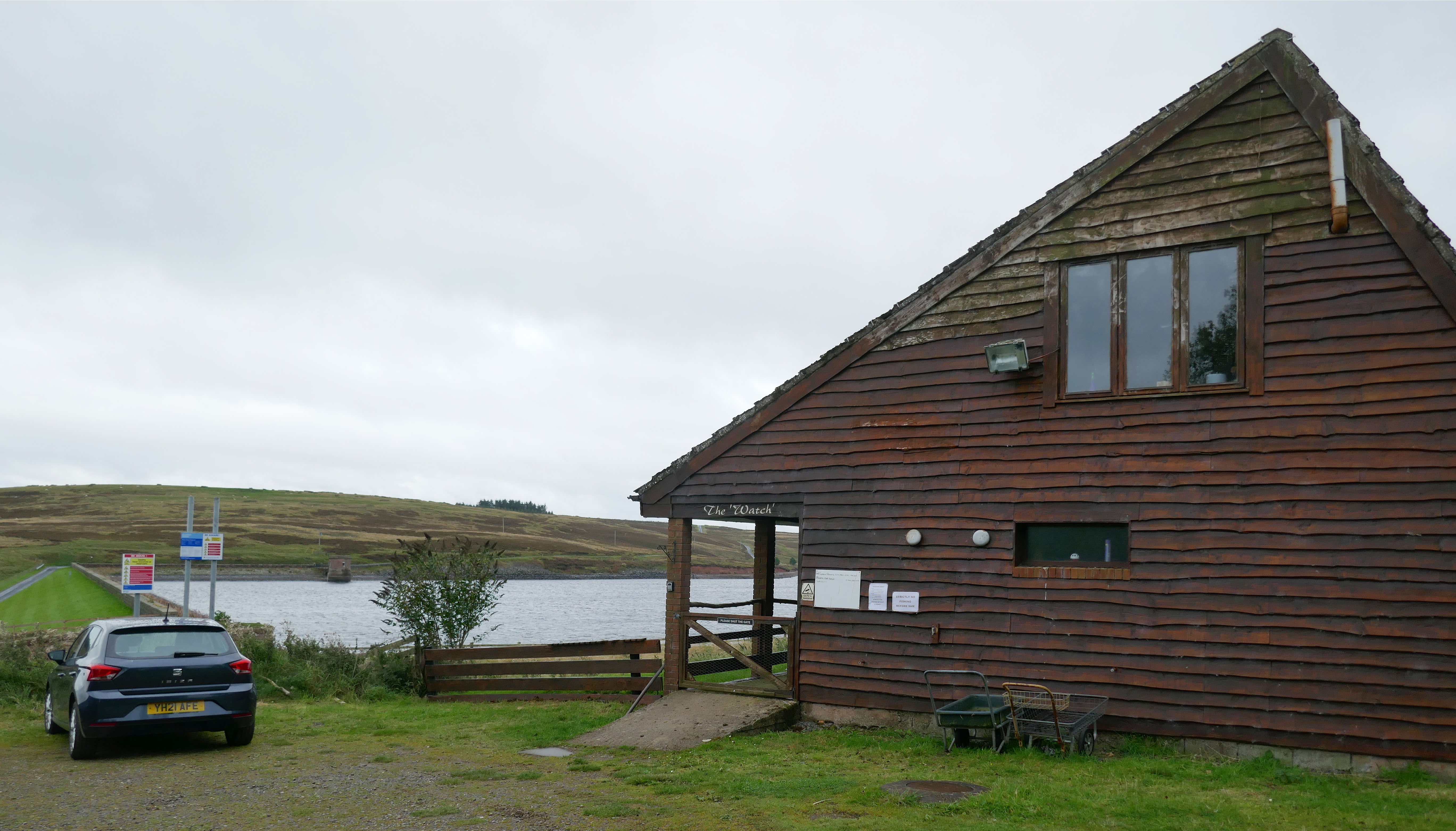
Watch Water Reservoir 2.55pm

Watch Water Reservoir 3pm

Watch Water Reservoir 3pm

Longformacus Dye Water Bridge 3.50pm

Longformacus Dye Water Bridge 3.50pm

Longformacus Cottages near Dye Water Bridge 3.50pm
Today was 16.1 miles in 6h 25m with 1650 feet (500m) ascent. Another good day on the hills, I enjoyed walking in the Lammermuirs.
Day 15 Wednesday 27th September 2023
Longformacus to Cockburnspath 18.7 miles 7.2h
Jan parked the car at the top of the hill in Longformacus, where I finished yesterday. It was dry, dull and 11°C. I started walking at 9.45am.

Longformacus Start 9.45am

Leaving the road near Longformacus 10.05am

Longformacus Owl Wood Path 10.35am

Lunch Stop Before Abbey St Bathans 12pm
I stopped for a bite to eat at 12pm on a conveniently positioned bench seat beside the path under a huge tree - homemade Eccles Cake and a chocolate bar.

Southern Upland Way Faded Sign Abbey St Bathans 12.25pm

Abbey Church at Abbey St Bathans 12.25pm

Abbey Church at Abbey St Bathans 12.25pm

Abbey Church at Abbey St Bathans 12.25pm

Abbey Church at Abbey St Bathans 12.25pm

Bridge over Whiteadder Water at Abbey St Bathans 12.30pm

Abbey St Bathan Whare Burn Track 12.40pm
Kist 13
Kist 13 is another one that is right beside the track. It's a rusty metal treasure chest set into the bank beside the track, about 8.5 miles from where I started in Longformacus.
I actually missed it on first pass as I hadn't seen an Ultreia post until the one at the stile. I thought that was the first one so I continued up the hill a short way before coming back to check the path before the Ultreia post and found it straightaway.

Track between river and wood

Kist 13 Treasure Chest Closed

Kist 13 Treasure Chest Open

Ultreia Post 2 from my 2nd Lunch Stop Bench Seat
I stopped for a 2nd lunch break (2nd Eccles Cake) on a seat near the Ultreia post after Kist 13.

Whiteburn WW1 Airfield Memorial 1.30pm

Whiteburn WW1 Airfield Memorial 1.30pm

Whiteburn WW1 Airfield Memorial 1.30pm

Path Diversion 2.05pm
It started raining at 2pm so I stopped to put full waterproofs on and took few photos of the last section running along close to the A1 road to the finish because my digital camera and phone aren't waterproof.

Cove Harbour near Cockburnspath 4.20pm

Cockburnspath Southern Upland Way End? 4.50pm
An information board on the outskirts of Cockburnspath appeared to be the official end of the route. What a disappointing place to finish! It's right next to the old A1 with the new A1 flyover noise and fumes not far away.
I ignored the sign and continued in to Cockburnspath village.

Cockburnspath War memorial and car park 4.55pm - THE END
I treated the War Memorial in the centre of Cockburnspath as the end point as I believe this is where it officially ended before the information board existed. I finished at 4.55pm.
In total it was 18.7 miles with 2875 feet (875m) ascent in 7h 10m from Longformacus to Cockburnspath.
Unfortunately, there isn't anywhere to celebrate having just walked the 218 miles from Portpatrick, no pub, hotel or cafe or anywhere else.
Why does such a great walk finish in a place like this? Why didn't it finish in St Abbs, a pretty fishing village like Portpatrick, just south of Cockburnspath - easily diverted to from Abbey St Bathans. It would have avoided walking with the noise and fumes of the heavy traffic on the A1 for a few miles near the end and with places to celebrate at the end.
Overall, I really enjoyed the variety in countryside that the walk takes you through. My favourite sections were between Bargrennan through Glen Trool over the hills to Galashiels. I'm pleased I did the High Level Alternative route between Beattock and Ettrick (even though I was feeling ill that day) - the views of the hills seemed to go on forever. I also like starting in pretty Portpatrick. I was really disappointed to finish in a place like Cockburnspath.
Southern Upland Way Part 1 Portpatrick to Beattock Blog Post - Click Here
Southern Upland Way Waymerks

Southern Upland Way Waymerks - Front Face
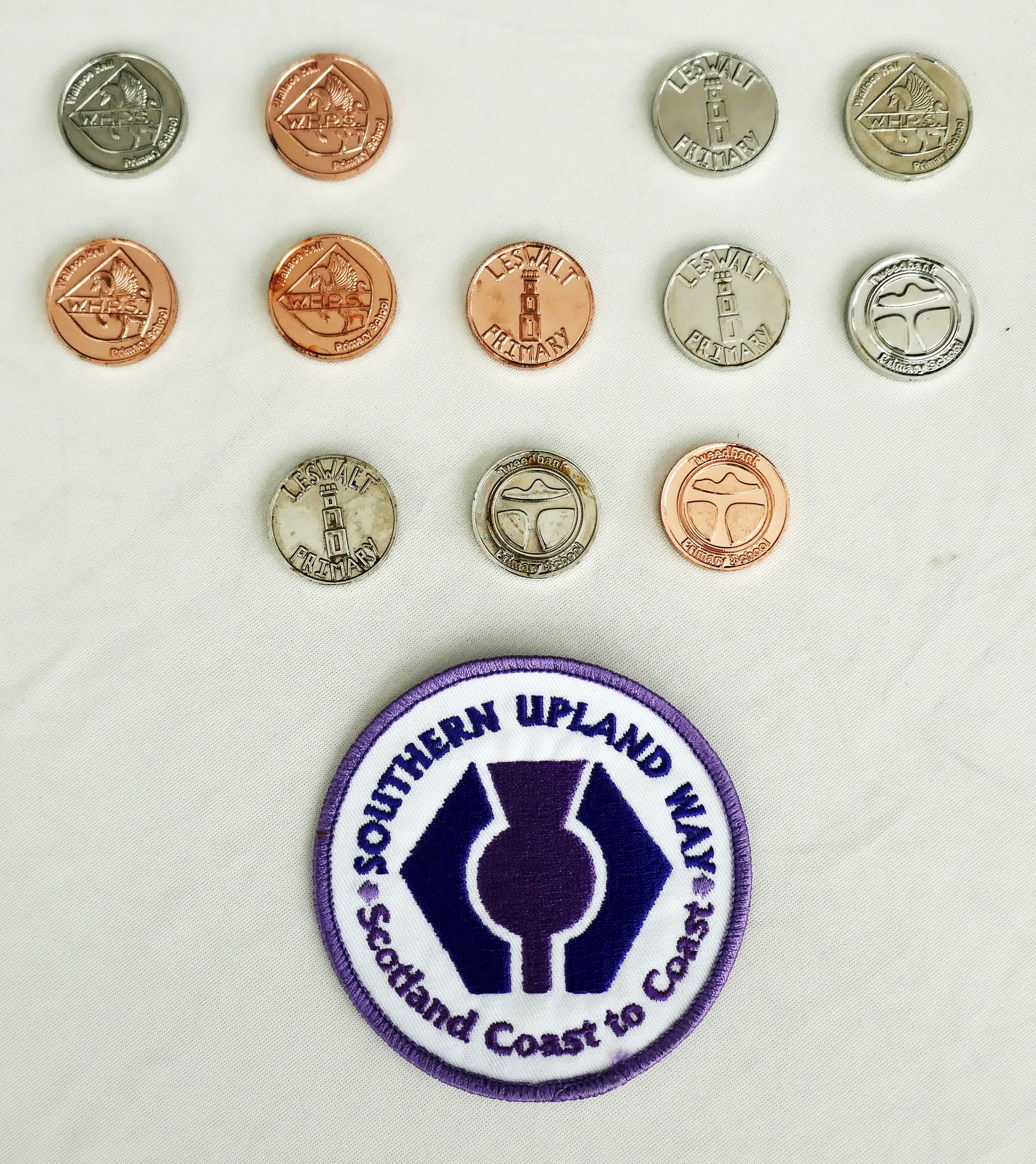
Southern Upland Way Waymerks - Rear Face
Top Row in both Images, left to right:
1. Hoard Kittiwake - Broad Moor / Knockquhassen
2. Hoard Fox - Glen Whan Woods
3. Missing - near Bargrennan - not on official alternative route that I did
4. Hoard Honey Bee - near Craigenbay
5. Hoard Striding Arches - Cloud Hill
Middle Row in both images, left to right:
6. Hoard Douglas Fir - Cogshead
7. Hoard 1st Bicycle - near Comb Head, Lowther Hills
8. Hoard Deer - Ettrick Head
9. Hoard Otter - near Traquair
10. Hoard The Tweed - Minch Moor
Bottom Row in both images, left to right:
11. Hoard King Duncan 1 - near Lauder
12. Hoard Train - near Twin Law, Lammermuirs (shown in 13th place)
13. Hoard Scottish Thistle - near Abbey St Bathans (shown in 12th place)
There are 13 Kist artworks with 13 different Waymerks. I found 12 as Kist 3 wasn't on the official alternative route that I took near Bargrennan. It added an extra dimension to the trek and extra interest, especially on dull days when the views weren't so extensive. I did waste a bit of time looking for them in places but most were right beside the trail, as in within a metre or so.
All the Waymerks are metal and some were very corroded such that the text was illegible. Some of the Kists were empty too. A quick email to DG Trails (Dumfries and Galloway Ranger Service) fixed that - they provide replacements and missing Waymerks on request. The Lammermuir Kist 12 has 2 compartments and also provided the cloth badge shown and a metal badge (now on my rucksack strap). At the end of the trek they also provided a certificate of completion. What an excellent service!
Totals
Total Distance: 218 miles
Total Walking Time: 97 hours
Average Distance per day: 14.5 miles
Average Walking Speed: 2.3mph
Camera
Mamiya 7 with 65mm lens - only used on first day in Portpatrick and along the coast.
Ilford Delta 400 @ 320 ISO for black and white photos on first day.
Panasonic Lumix TZ100 digital camera for colour photos along the route for my blog posts.
Other Equipment
Satmap Active 20 GPS with OS 25k maps programmed with my route
Harvey 40k map of Southern Upland Way
Kestrel 2000 pocket anemometer - for wind speeds and temperature/wind chill