This is the Dave Butcher photo diary of a Chamonix to Zermatt Haute Route ski mountaineering trip in 1993. At the time I just made a few small prints but when I built my first website in 2003 I scanned those prints on a flatbed scanner to add them to the site with my daily notes from the trip. Most of the negatives remained unused and unseen, until now. This post contains over 100 images from that trip and better represents the Ski Haute Route and the landscapes it passes through from Chamonix in France to Zermatt in Switzerland. It is probably the best known ski tour in Europe, if not the world.
We took just over 6 days to complete the route and went via Verbier, hoping for better weather than the other route through the Grand Combin range. The weather was pretty good the whole way, which was lucky for us.
Preparation
I didn't have a fitness plan but had a week skiing in Solden, Austria, in January and another week skiing around Zermatt, Switzerland in early March. I had also done a few trips in February and March to Scotland to hike/climb quite a few Munro's (Scottish mountains over 3000 feet / 914 metres). Finally, at the end of March I also had a couple of sessions at the Sheffield Dry Ski Slope. This is like skiing on toothbrushes so it's quite different to skiing on snow but it toned the muscles up a bit.
I also live in the English Peak District and walked the hills at the weekends.
Our Guides
Our mountain guides were Brian Hall (from Derbyshire near where I live) and Jon de Montjoye (English but now living in Vallorcine near Chamonix). There was also an aspirant (trainee) mountain guide, Richard Masters, an instructor from Glenmore Lodge in the Cairngorms.
 |
| Our Haute Route Guides - Brian Hall left, John de Montjoye right, aspirant guide Richard centre, Schonbielhutte near Zermatt ski Haute Route day 6; 100635 |
Our Group
Mark Rogerson (pathologist from Northwich), John Cameron (garage owner and ski instructor from Perth), Mark McDonnell (marketing manager), Michael and 12 year old son Mathew from Toronto, Gian (Radiologist), John Carney (on extended 9 week leave from his job), Team Purple (7 climbing friends who all wore purple Buffalo windroofs and were dubbed Team Purple as a result, including Kate and Patrick).
We were also joined by professional photographer Jess Stock and Vaila Macdonald (his wife and extreme ski world champion). Jess was taking photographs for a book on ski mountaineering around the world with a chapter and one iconic tour for each month of the year.
Our guides Brian and Jon had arranged for the group to have a practice day using the Le Tour ski lifts to practise off-piste technique, including side slipping down steep slopes and abseiling over an overhang while roped up. We split into 2 groups and I was mainly with Jon and Team Purple was mainly with Brian.
Ordering Black and White Fine Art Prints
Prints are available using the 6 digit number at the end of the caption to uniquely identify the negative to help ordering - just go to the Contact page on my davebutcher.co.uk website and send me a message with this number and I will sort the details with you from there.
Wednesday 14th April 1993 Travel to Chamonix
Jan dropped me off at Manchester Airport in the morning for my flight to Geneva Airport. Then I caught the train to Martigny where I changed to the mountain railway to Chamonix for a spectacular ride through the mountains. Then a walk from the station through Chamonix to the Hotel L'Arve.
 |
| Chamonix Hotel de l'Arve, April 1993 |
Thursday 15th April 1993 Argentiere Skiing
I decided to catch the bus to Argentiere and ski there for the day. On returning to the hotel my room-mate had arrived, Mark McDonnel. He'd also arrived early to have a day skiing before the trip started.
Friday 16th April 1993 Argentiere Skiing, Evening Group Meeting
We agreed to go to Argentiere and ski the Grands Montets a few times to find our touring legs. It was a good day for skiing around the pistes too, there was blue sky with clouds below us. Grands Montets is a good viewpoint for photos as well.
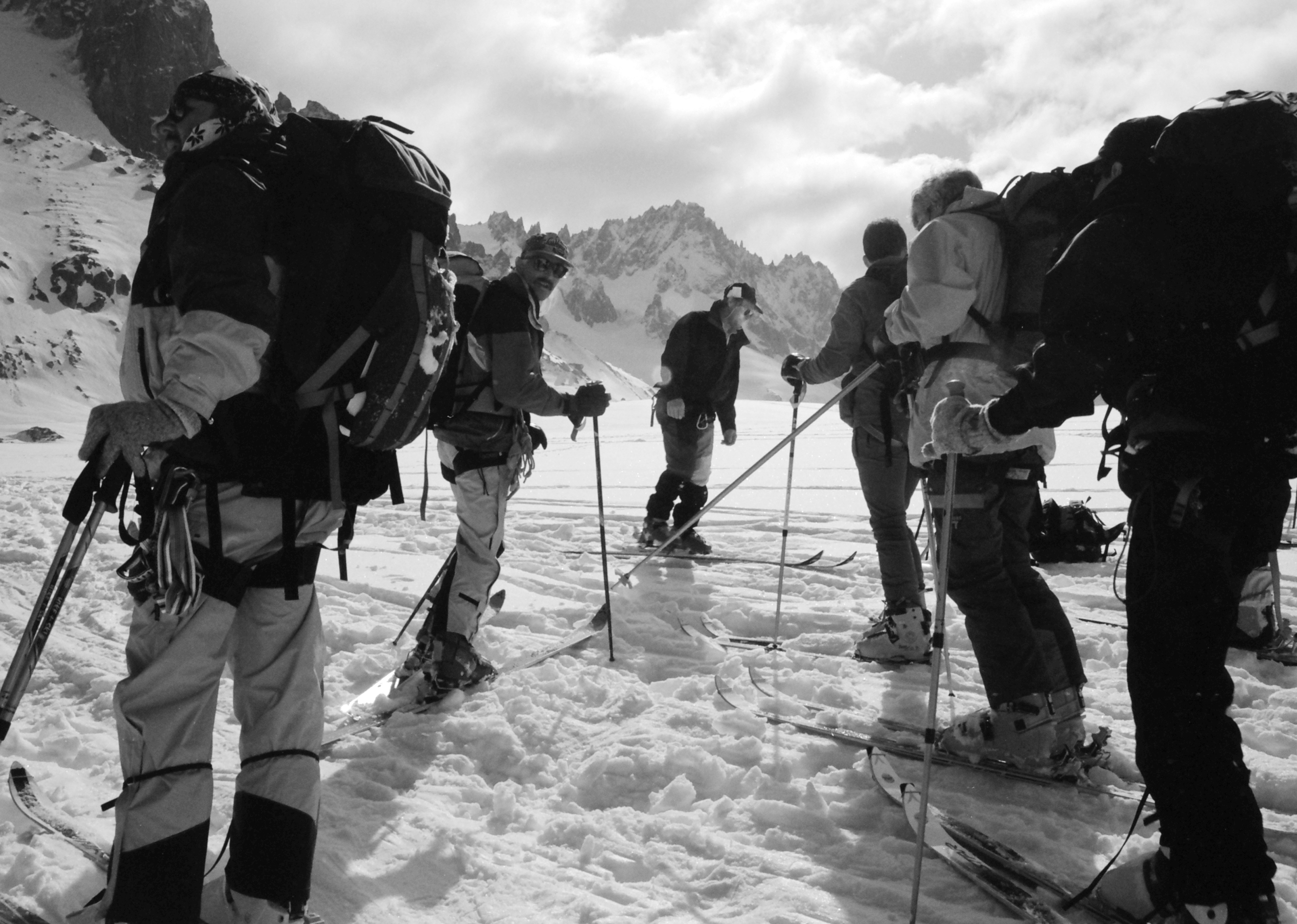
There was quite a group of people in the car park outside the hotel when we returned from skiing and it turned out they were in the same group as us, waiting to ski the Haute Route. I had no idea there would be so many, there were 15 of us in total. At 7pm we all collected downstairs for the welcome meeting and kit check with our guides Brian Hall and Jon de Montjoye. In total the group was 20 people including us clients, 3 guides, Jess and Vaila.
Saturday 17th 1993 Group Preparation Day
We were picked up from the hotel and driven up the road to Le Tour so that, before starting the tour we could have a day with the guides checking out our off-piste skiing abilities and other skills, like using an ice axe to self-arrest. We also had a couple of goes at abseiling with our skis on. We used the lifts to get around the Le Tour area and then skied down off-piste. After lunch we skied down towards Vallorcine and then put skins on the underside of our skis so that we could ski uphill. After the lists closed for day we skied down to the Le Tour car park below where our transport back to Chamonix was waiting.
We were then split into 2 groups which we mostly kept for the trip. There was a group of 7 so they were kept together in Brian's group with one or two others and the rest went with Jon. It turned out we were a faster group which suited my pace better and gave me more chance for taking pictures as there was always a group behind so no chance of being left behind or getting lost!
Day 1, Sunday 18th April 1993
We started in Argentiere (1251 m) by taking the early lifts up to the Grand Montets (3250 m). Then at 9.10am it was time to put skis on and we skied down with Jon to the Argentiere Glacier. Here we stopped to put skins on and at 10.15am started up the Chardonnet Glacier to the Col du Chardonnet (3323 m). We stopped for a break to let the other group catch up then, after 10 minutes, continued to the col.
We reached the Col du Chardonnet at 12.45pm. There was quite a queue to descend here and when our turn came the steep descent was aided by a rope so that we could abseil-cum-sideslip down safely and reasonably speedily. I had skied this same route to Cabane du Trient last year with Peter Cliff but the descent from Col du Chardonnet this year was more difficult. I went down 5th and there was soft snow cut into a groove just wider than my skis, rather than the grippy smooth ice of last year. You had to be careful not to put the tips or tails of the skis into the snow bank on either side as it tried to tip you over.
We regrouped near the base of the col. Then it was around to the foot of the next col for a lunch break while we waited for the other group. It was hot now with the sun beating down on us. After 45 minutes and still no sign of them we started the climb up to the Fenetre de Saleina (3261 m). Jon and Mark R skied up making lots of kick turns but everyone else, including me, walked up in the bucket steps already made in the deep snow carrying our skis.
From the col we all put skis back on and skied down a gentle slope of heavy snow continually stepping up onto the uphill ski to keep going without losing too much height. Once across the Plateau du Trient we stopped to put skins on and skied up the last bit to the Cabane du Trient (3170 m) at 5pm for the first night. Dinner was at 6.30pm so we had time for lots of weak tea to rehydrate and then a beer or two.
My Nikon FM slr camera broke a shutter blade and was unusable for the rest of the trip.
 |
| Argentiere Glacier Group, ski Haute Route Day 1; 100116 |
 |
| Chardonnet Glacier from Argentiere Glacier, ski Haute Route Day 1; 100117 |
 |
| Chardonnet Glacier, ski Haute Route Day 1; 100118 |
 |
| Chardonnet Glacier ascent, ski Haute Route day 1; 100119 |
 |
| Chardonnet Glacier view north to Chamonix valley and Aiguille Rouges, ski Haute Route day 1; 100120 |
 |
| Steep ascent of Chardonnet Glacier to Col du Chardonnet, ski Haute Route day 1; 100122 |
 |
| Aiguille Vertes and Grands Montets from Chardonnet Glacier, ski Haute Route day 1; 100123 |
 |
| A short break at the top of the first steep section on Chardonnet Glacier, guide Jon de Montjoye on right, ski Haute Route Day 1; 100124 |
 |
| A short break at the top of the first steep section on Chardonnet Glacier, Grands Montets background right, ski Haute Route Day 1; 100126 |
 |
| Ascent of final section of Chardonnet Glacier to Col du Chardonnet, ski Haute Route Day 1; 100128 |
 |
| View above Col du Chardonnet, ski Haute Route Day 1; 100129 |
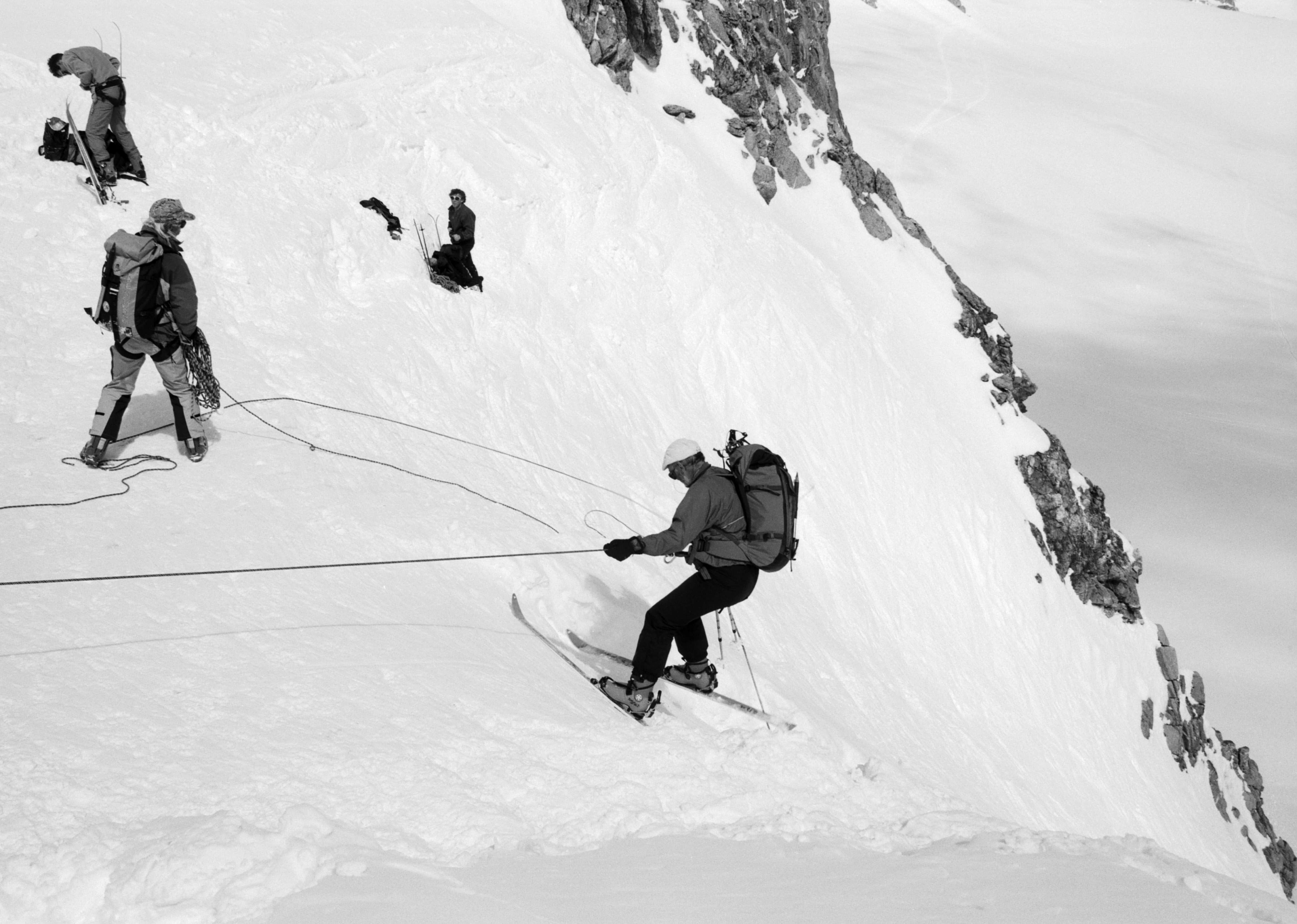 |
| Ski abseil from Col du Chardonnet down steep Swiss side, guide Jon de Montjoye on left, ski Haute Route Day 1; 100132 |
 |
| Ski abseil from Col du Chardonnet down steep Swiss side, ski Haute Route Day 1; 100131 |
 |
| Assembly point after Col du Chardonnet descent, looking at base of Aiguille d'Argentiere. Col du Chardonnet out of sight in dip between 2 rocky ridges, ski Haute Route Day 1; 100135 |
 |
| Fenetre de Saleina Approach from Col du Chardonnet, ski Haute Route Day 1; 094415 |
 |
| Fenetre de Saleina View to Aiguille de la Neuve, ski Haute Route Day 1; 094421 |
 |
| Taken below Cabane du Trient on ski Haute Route. Note the supply helicopter left of the hut, ski Haute Route Day 1; 094426 |
 |
| Aiguilles Dorees from Cabane du Trient in the afternoon, ski Haute Route Day 1; 094433 |
Day 2, Monday 19th April 1993
We were up at 6.30am, dressed and packed our rucksacks before breakfast at 7am, which was bread and jam with tea. After a quick trip to the toilet we all gathered outside to put our skis on at 7.30am. It was another sunny day.
We skied with Brian steeply downhill on icy snow while keeping to the right flank of the descent route, side slipped a steep section above a heavily crevassed Trient Glacier and then skied the traverse to the foot of the Col des Ecandies (2796 m). From here we took our skis off, put them on our shoulders, and walked up to the col in the deep bucket steps already there in the snow. No-one skied up this one. Then at the top of the col it was skis on again before we skied down in deep powder and then heavily mogulled churned up slopes with patches of breakable crust. From the bottom there was a good run on spring snow then avalanche debris before skiing through some woods. It was heavy snow from here to a chalet cafe above the village of Champex at 11am. Mark M fell just before the trees and split his lip in the breakable crust snow and Gian spent about 15 minutes doing a temporary fix to hold Mark's lip together. It would need stitches later.
We stopped at the cafe drinking cold Coke and waited for the other group, they turned up just 15 minutes later. Then we skied down a few hundred yards to where the snow ended, took our skis off, and walked the rest of the way to the village of Champex (1465 m) which we reached at about 11.30am. We had lunch in a restaurant in the village by the lake, I had roast beef and rosti - very nice! It was sunny and warm with lots of ice on the surface of the lake.
From Champex the snow ran out so at 1.30pm we were ferried in taxis to Verbier (1490 m), where I bought a Nikon AF2 compact for 250 SFr (about £115) to replace my broken Nikon FM slr. From Verbier we met at 4pm at the Attelas lift which we took to the top. Then we traversed around the mountainside on quite unstable slopes of heavy snow, with lots of snow slides around us, to get above the Cabane du Mont Fort (2457 m) so that we could ski down to it for our second night, reaching it at 4.30pm.
We had a big evening meal of vegetable soup cum stew followed by spaghetti, mince and salad. It had stayed hot and sunny all day again.
 |
| View southwest from Cabane du Mont Fort near Verbier, ski Haute Route Day 2; 100201 |
 |
| Cabane du Mont Fort in afternoon near Verbier, ski Haute Route Day 2; 100203 |
 |
| Cabane du Mont Fort view to our route east tomorrow near Verbier, ski Haute Route Day 2; 100206 |
Day 3, Tuesday 20th April 1993
We were up in time for 6am breakfast of bread, jam and tea, and skiing by 7.10am on another cold bright morning. We were with Jon today and there were just 5 of us as Michael and Matthew were with the other group.
The first part was skiing on a pisted track with lots of avalanche debris to ski through. Some of the bits were the size of houses brought down by the hot weather - we had watched some of it sliding down yesterday afternoon. As we went higher we made our own way up the glacier ignoring the tracks of other skiers. Both groups were together at this stage. The last section to the col was steep and icy and the other group fell well behind. We reached the Col de la Chaux at 8.45am and had a short break while both groups assembled together.
Then we had a long downhill section on good snow before skinning up to the Col du Momin (3003 m) followed by a slight downhill and a long hot slog climbing most of the way, with one small downhill section that we kept skins on for. The last bit was steep and icy and the skis slipped around a bit until we reached a small shelf 100 metres or so below the summit of La Rosablanche (3336 m) where we took our skis off. From here it was just a short steep snow climb to the top at 11am. I followed Jon and Mark R but most stayed below. The view was spectacular so I stayed on top taking lots of photos for 15 minutes or more. It was sunny and hot with clear blue skies.
I came down and joined the others in having a snack. The other group started arriving from 11.30am. We took the skins off our skis and left at 11.45am. The snow was deep, heavy, wet and difficult to ski. As well as this our route to the hut was at risk from avalanches so we skied well spaced out. Despite the urgency we had to do lots of traverses in the tricky snow to descend the steep slopes and reached the Cabane de Prafleuri (2624 m) at 1.30pm.
We spent most of the afternoon sunbathing outside the hut, it was very hot. At the refuge we had to fend for ourselves (no guardian to cook for us). In fact Jess and Vaila cooked for us as a thank you for allowing them to join our group. We were relieved to be able to unload the heavy food and drinks from our rucksacks that we had been loaded up with in Verbier! I was carrying about 2kg of food which I really noticed when skiing downhill doing turns.
 |
| Cabane du Mont Fort after Verbier ski area closed, ski Haute Route Day 2; 100209 |
 |
| Cabane du Mont Fort from Haute Route, ski Haute Route Day 3; 100217 |
 |
| Our guide Jon de Montjoye on Col de la Chaux near Verbier, ski Haute Route Day 3; 100220 |
 |
| Col de la Chaux view west and Vaila Macdonald near Verbier, ski Haute Route Day 3; 100221 |
 |
| Col de la Chaux descent near Verbier, ski Haute Route Day 3; 100224 |
 |
| Traverse across plateau between Col de la Chaux and Col de Momin near Verbier, ski Haute Route Day 3; 100226 |
 |
| Approaching ascent to Col de Momin near Verbier, ski Haute Route Day 3; 100230 |
 |
| Aspirant guide Richard Masters left, near Col de Momin top, ski Haute Route day 3; 100231 |
 |
| Jon de Montjoye guide, on La Rosablanche near Verbier with Matterhorn in background right of centre and Dent Blanche to his left, ski Haute Route day 3; 100233 |
 |
| La Rosablanche view northwest to Verbier Mont Fort ski area, ski Haute Route day 3; 100302 |
 |
| View from La Rosablanche summit southwest to Grand Combin, near Verbier, ski Haute Route day 3; 100304 |
 |
| La Rosablanche summit view south to La Sale and Pleureur, ski Haute Route day 3; 100306 |
 |
| Mark Rogerson left and John Cameron right, outside Cabane de Prafleuri, ski Haute Route day 3; 100309 |
 |
| Drying gear outside Cabane de Prafleuri, ski Haute Route day 3; 100310 |
 |
| Richard Masters aspirant guide sitting on window ledge at Cabane de Prafleuri, ski Haute Route day 3; 100312 |
Day 4, Wednesday 21st April 1993
Breakfast was bread, jam and tea at 6am and there were 7 of us in our group as Michael, Matthew and Gian joined us. We were skiing with Brian by 7am and skinned up to the Col des Roux above the hut at 8am where we removed our climbing skins from the skis.
It was a steep descent from the col followed by a very tiring slightly downhill traverse across steep snowy slopes covered in fresh avalanche debris. The tiring bit was continually stepping onto the uphill ski to avoid losing height. The last section at the head of the valley was a good descent to the end of the frozen Lac des Dix (2360 m) where we stopped for photos and sun cream as there were blue skies and it was hot.
After our short break we put skins on the skis and zig-zagged up the steep slope at the head of the valley. Gian took us off-course for a few hundred metres but we soon realised and were back on track, caught up with Brian and soon found ourselves at the Pas du Chat. From here we traversed the slopes to follow a snow covered moraine bank that led us up to the back of the Tete Noir. We were to the west and quite a bit above the hut so we took the skins off our skis. From here we skied down on good snow until near the hut when it became heavy wet snow. We walked the last 50 metres carrying our skis over our shoulders and arrived at the Cabane des Dix hut (2928 m), a busy hut, at 1pm. There were fantastic views all around from here.
I had sausage and rosti at 13 SFr for lunch and drank lots of tea to rehydrate at 1.50 SFr per litre as I only carried 1 litre of water. I refilled my aluminium Sigg bottle with 4 bottles of mineral water at 4 SFr for 300ml. Later we switched to a beer or two at 4 SFr per small can. It was a good modern spacious hut. The weather closed in late afternoon and there was light snow so we were pleased that we reached the hut while it was good weather.
 |
| Mark Rogerson at avalanche field above Lac des Dix, ski Haute Route day 4; 100316 |
 |
| Crossing avalanche field above Lac des Dix, ski Haute Route day 4; 100317 |
 |
| Our group having a break at south end of Lac des Dix, ski Haute Route day 4; 100321 |
 |
| Ascent of the Pas du Chat above south end Lac des Dix, ski Haute Route day 4; 100326 |
 |
| View north to Lac des Dix from ascent of the Pas du Chat, ski Haute Route day 4; 100327 |
 |
| Pas du Chat ascent, ski Haute Route day 4; 100328 |
 |
| Approaching Pas du Chat, ski Haute Route day 4; 100329 |
 |
| Above Pas du Chat, John Cameron, ski Haute Route day 4; 100331 |
 |
| View north to route from Lac des Dix and Pas du Chat, ski Haute Route day 4; 100332 |
 |
| View near Tete Noire above Cabane des Dix, ski Haute Route day 4; 100334 |
 |
| Uphill skiing on moraine bank at around 2800m north of Tete Noire near Cabane des Dix, ski Haute Route day 4; 100336 |
 |
| Tete Noire near Cabane des Dix with Mont Blanc de Cheilon range behind, ski Haute Route day 4; 100402 |
 |
| Descent to Cabane des Dix near Tete Noire, ski Haute Route day 4; 100404 |
 |
| Cabane des Dix with Pointes de Tsena Refien left and Mont Blanc de Cheilon right from near Tete Noire, ski Haute Route day 4; 100407 |
 |
| View east towards Dent Blanche (partly behind and left of flag) from Cabane des Dix, ski Haute Route day 4; 100412 |
Day 5, Thursday 22nd April 1993
It was breakfast of the usual bread, jam and tea at 5.30am so that we were skiing with Jon at 6.30am with the same group as yesterday. It was a short distance of a few hundred metres down to the glacier where we put skins on.
We headed up the shallow slope to begin with then it steepened and was covered with 5 cm or so of fresh snow on a firm base. After this we crossed the crevassed slopes of the Glacier de Tsena Refien close to the Pointes de Tsena Refien.
Next was the Col de Tsijiore Nouve overlooking the very impressive Mont Blanc de Cheilon (3870 m). From here we skied southwest under some very large ice cliffs and over a heavily crevassed area using several snow bridges and lots of zig-zags to the Col de Brenay, a large plateau which heli-skiers were using as a drop-off point to ski back to Arolla in the valley below. It seemed somewhat perverse that it had taken us 5 days to reach the point they had reached in 5 minutes!
We dumped our gear on the plateau and quickly skied up to the top of the Pigne d'Arolla (3796 m) at 9.50am. There was blue sky and a few clouds, particularly towards the Matterhorn which we didn't see. We took the skins off our skis and skied back to our rucksacks and continued down about another hundred metres to get out of the cold wind where we stopped for a short lunch break.
The weather started to turn and we skied down slightly mogulled slopes followed by a steep traverse through some thick cloud to the Cabane des Vignettes (3160 m) which we reached at 11.20am. We took our skis off and carried them as we walked the last 50 metres to the covered walkway leading to the hut entrance.
I had sausage and rosti for lunch for 12 SFr and lots of tea before we had one or two beers after we felt we were rehydrated, judged by the number of times we went to the toilet!
The hut has a very impressive position on top of high cliffs and is built of stone. The outside toilet is the most impressive of all, reached by a narrow 20 metre long metal walkway, both of which were bolted to the side of a cliff with an enormous drop beneath the toilet seat!
By 2.30pm the weather had closed in completely, turning colder with blizzards raging outside. Without a doubt this was the most spectacular hut of the trip.
 |
| Mont Blanc de Cheilon from Glacier de Tsena Refien, ski Haute Route day 5; 100426 |
 |
| Ascent from Col de Tsijore Nouve, ski Haute Route day 5; 100427 |
 |
| Helicopter landing at Col de Brenay, ski Haute Route day 5; 100429 |
 |
| View southwest from Pigne d'Arolla to Pointe d'Otemma at end of ridge on left, snowy dome of La Serpentine on right, ski Haute Route day 5; 100432 |
 |
| Dent Blanche view from Pigne d'Arolla, ski Haute Route day 5; 100434 |
 |
| Mont Blanc de Cheilon from Pigne d'Arolla, ski Haute Route day 5; 100436 |
 |
| Matterhorn and Dent d'Herens from Pigne d'Arolla, ski Haute Route day 5; 100437 |
 |
| Dave Butcher on Pigne d'Arolla summit with Matterhorn and Dent d'Herens in background, ski Haute Route day 5; 100500 |
 |
| Lunch break below summit of Pigne d'Arolla, Mark Rogerson, ski Haute Route day 5; 100504 |
 |
| View East from Pigne d'Arolla over Mont Collon to Matterhorn and Dent d'Herens, ski Haute Route day 5; 100509 |
 |
| Descent to Cabane des Vignettes from Pigne d'Arolla, ski Haute Route day 5; 100510 |
 |
| Descent to Cabane des Vignettes from Pigne d'Arolla, ski Haute Route day 5; 100511 |
 |
| Final traverse on descent to Cabane des Vignettes from Pigne d'Arolla, ski Haute Route day 5; 100515 |
 |
| View back to descent to Cabane des Vignettes from the hut, ski Haute Route day 5; 100517 |
 |
| Cabane des Vignettes view south to Mont Collon (left) and l'Eveque (centre), ski Haute Route day 5; 100519 |
 |
| Cabane des Vignettes view southwest to Petit Mont Collon, ski Haute Route day 5; 100521 |
 |
| Cabane des Vignettes view from covered entrance walkway to l'Eveque, ski Haute Route day 5; 100522 |
Day 6, Friday 23rd April 1993
Breakfast was at 5am, the earliest that the hut guardian would do it. There was a long queue for the toilet as we left - fortunately, I had taken the precaution of going before breakfast. It was just about first light as we left at 6am. We needed crampons just to get out of the hut door and along the covered walkway because of the sheet ice. Then there was a steep drop on the left hand side as we traversed carrying our skis across to the top of the main route down from the hut. Once across this we changed from crampons to skis and with Brian we were off with 3 cols to cross.
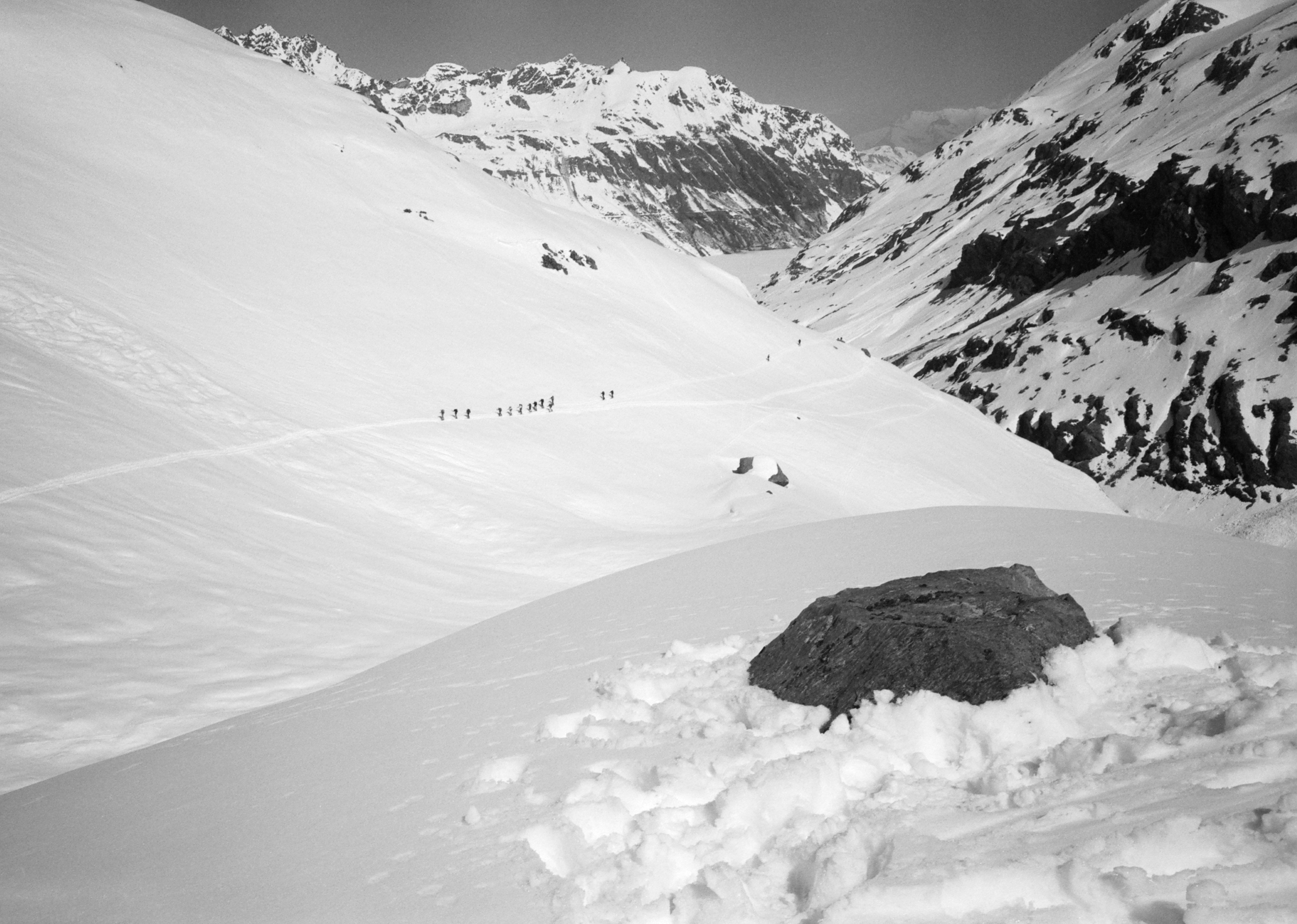
We soon skied down to the Col de Charmotane (3016 m) below, where we put skins on our skis and skied up in clouds but visibility wasn't too bad. The slope was steep for last section up to the first col of the day, the Col de l'Eveque 3392 m. The clouds lifted slightly but still no distant views. It was a good ski down on a slightly moguled slope at the top, with a traverse round a rocky bit called La Vierge and then down to the plateau of the Haut Glacier d'Arolla, opposite the Refuge des Bouquetins.
We had a brief stop here to switch our skis from downhill to uphill mode by adding climbing skins and releasing the binding so that we could slide the ski forward with longer strides. It was a long easy skin most of the way up to the next col but with a sting in the tail of very steep ice near the top so we stopped just below this to put ski crampons on. Then, after lots of tight kick turns on the ice by flicking the heel to bring the ski around quickly, we reached the top of the second col, the Col du Mont Brule 3213 m. We had a long break and lunch at the top waiting for the others and I took a few photos of the view to the east.
Then it was time to take off the skins before moving off for a long downhill traverse to reach the plateau about 100 m below the Haut Glacier de Tsa de Tsan in clouds. It was a bit cooler now and with a cold breeze.
It took us 2.5h to skin up to the Col de Valpelline 3568 m but there were no views to the Matterhorn because of thick cloud. Shame, it should have been one of the highlights of the trip.
Brian Hall gathered us all around and told us to ski close together and follow him as the route was heavily crevassed. We took the skins off our skis and skied down closely following Brian, as instructed. The Stockji Glacier was covered in about 30 cm of fresh powder snow and was indeed heavily crevassed. Part way down Jess Stock thought it would make a good shot for the book if we skied into a crevasse with a snow bridge part way down and back out again, which several of us did. He photographed each of us as we skied out of the crevasse. Probably not the most sensible thing I've ever done!
Then we skied south of Stockji to the Tiefmatten Glacier. It was quite dull now and my glacier glasses were too dark and low contrast such that I couldn't see the snow clearly around my skis, so I switched to goggles. These were much better but I had to be careful that they didn't mist up which was why I hadn't worn them much on this trip. We skied below some enormous ice cliffs keeping fingers crossed nothing would break off as we skied past.
Lower down we traversed along very soft snow and breakable crust until we reached the foot of the moraine below the Schonbiel Hut. Finally, we put skins on again to ski up the glacier, onto the snow covered moraine and skinned part way up a steep snow slope above the hut. Then it was time to take the skins off and have a final few hundred metres ski downhill to reach the Schonbielhutte (2694 m) at 2.30pm for our last night in the mountains.
The hut was empty except for our group. I had sausage and rosti 13 SFr for lunch and lots of tea to rehydrate. The evening meal was pork fillet, a bottle of wine was 24 SFr and a small beer 4 SFr.
The toilets were a short distance from the hut and were very primitive but they had the most spectacular view I've ever seen from a toilet, across the valley to the north face of the Matterhorn!
It was a long day which ended with us sitting on the terrace of the Schonbielhutte sipping beer looking straight across the valley at the north face of the Matterhorn (4478 m) as the clouds parted later on. Quite a way to end the day.
 |
| Dawn view northeast from near Cabane des Vignettes, ski Haute Route day 6; 100528 |
 |
| Instructions from our guide before the descent from Col de l'Eveque, Mark Rogerson left, Vaila Macdonald right, ski Haute Route day 6; 100530 |
 |
| La Vierge traverse near l'Eveque with Haut Glacier d'Arolla below and Col du Mont Brule top right, ski Haute Route day 6; 100531 |
 |
| Descent to Haut Glacier d'Arolla near La Vierge and l'Eveque, ski Haute Route day 6; 100532 |
 |
| Descent from La Vierge traverse to Haut Glacier d'Arolla with line of skiers heading for Col du Mont Brule right of centre, ski Haute Route day 6; 100533 |
 |
| Skiing up Haut Glacier d'Arolla towards Col du Mont Brule, ski Haute Route day 6; 100534 |
 |
| Start of ascent from Haut Glacier d'Arolla to Col du Mont Brule, ski Haute Route day 6; 100535 |
 |
| Looking down at final sectipon of ascent to Col du Mont Brule, ski Haute Route day 6; 100536 |
 |
| Dent d'Herens from Col du Mont Brule, Matterhorn hidden in clouds on left, ski Haute Route day 6; 100600 |
 |
| Col du Mont Brule group lunch break, ski Haute Route day 6; 100604 |
 |
| Descent from Col de Valpelline on Stockji Glacier, ski Haute Route day 6; 100608 |
 |
| Jess Stock photo session at a Stockji Glacier crevasse, ski Haute Route day 6; 100610 |
 |
| Skiing into Stockji Glacier crevasse for photos, ski Haute Route day 6; 100612 |
 |
| View up from Stockji Glacier crevasse, ski Haute Route day 6; 100613 |
 |
| Stockji Glacier Descent, ski Haute Route day 6; 100616 |
 |
| View east towards Zermatt. from Stockji Glacier, ski Haute Route day 6; 100619 |
 |
| Stockji Glacier Photo Shoot - Jess Stock and Vaila Macdonald, ski Haute Route day 6; 100621 |
 |
| Stockji Glacier descent to Zmutt Glacier, ski Haute Route day 6; 100623 |
 |
| View back to our Stockji Glacier descent route, ski Haute Route day 6; 100626 |
 |
| Approach to Schonbielhutte, ski Haute Route day 6; 100629 |
 |
| View east from Schonbielhutte over Zmutt Glacier towards Zermatt, ski Haute Route day 6; 100631 |
 |
| View of Stockji Glacier snout from Schonbielhutte - not our descent route! Ski Haute Route day 6; 100632 |
 |
| Matterhorn from Schonbielhutte late afternoon, ski Haute Route day 6; 100633 |
 |
| Our group in the Schonbielhutte dining room waiting for dinner, ski Haute Route day 6; 100636 |
Day 7, Saturday 24th April 1993
Breakfast was at 6.30am and we started skiing at 7.30am. It was quiet in the hut, most on the Haute Route carry on to Zermatt instead of stopping here.
We skinned uphill away from the hut for a few minutes following the route that we came in from, then traversed a steepish slope down to the moraine. From here we continued up to the edge of the Schonbiel Glacier on fresh snow where we stopped to take off the skins from our skis and convert them into downhill mode by clipping the heel down.
We skied down the Schonbiel Glacier in fresh snow on a firm base. A bit lower down there was a junction with the routes into Zermatt, we chose the right hand side of the valley and skied through dozens of small clear round marbles of ice glistening in the sun, mostly 2 to 5 cm in size. Then we made our way down through the trees, along flat sections where we were continually stepping onto the uphill ski to keep moving until we stopped and took off our skis and carried them to walk the last 15 minutes to the Restaurant Stafelalp at 9.30am. We had hot drinks while we waited for the others, I had a hot chocolate.
Jess took the team photo outside the restaurant (although I've never seen it which is shame). Then at 10.15am we skied down the Weisse Perle ski piste on reasonable snow where we had a leisurely ski down to the flesh pots of Zermatt (1614 m) ending at 10.45am just 100 metres from the Furri lift station as the snow ran out!
We caught the lift down to Zermatt and walked through the town to the Hotel Bahnhof near the station by 12pm. It was packed, so John Cameron and I went to another nearby hotel and had lunch there. I had schnitzel and chips for a change. We headed back to the Hotel Bahnhof for the agreed meeting time of 1pm before walking down the road to get a taxi-minibus to take us back the 2.5 hours to Hotel l'Arve in Chamonix.
 |
| Dent d'Herens and Stockji Glacier from Schonbielhutte, ski Haute Route day 7; 100712 |
 |
| Descent from Schonbielhutte to Zermatt on Zmutt Glacier, ski Haute Route day 7; 100714 |
 |
| Matterhorn from Zmutt Glacier, ski Haute Route day 7; 100716 |
 |
| Matterhorn from near Zermatt, ski Haute Route day 7; 100718 |
 |
| Stafelalp Restaurant above Zermatt with Mark Rogerson on right and Gian, ski Haute Route day 7; 100721 |
 |
| Stafelalp Restaurant above Zermatt with guides Brian Hall, Richard and Jon de Montjoye, ski Haute Route day 7; 100722 |
Travel Home Sunday 25th April 1993
After breakfast and saying goodbye to everyone from our group that were still there I walked up to the station and caught the train to Martigny. From there I caught a train to Geneva Airport and flew back to Manchester Airport with British Airways. My wife met me and drove me home, I was too tired to drive!
Summary
What a fantastic trip in mostly good weather with excellent company. We were lucky with the weather as we heard several stories of people who had bailed out on previous trips. Apparently, some years most people make it and other years very few manage to do the whole route - all depending on the weather and snow conditions.
I was a steady skier before I started, having been skiing for 5 years and skied 3 Munro's (the highest mountains in Scotland over 3000 feet / 914 metres) in Scotland. However, in Team Purple, who were all climbers, there were a few who hadn't skied that much including 1 guy who had only skied for 7 days ever! He seemed to snowplough the whole way and I suspect that was part of the reason that the other group was moving slowly at times. Everyone successfully completed the trip.
I was very physically tired at the end of the trip but soon picked up after a couple of days. My weight was 69kg when I left home and 67kg on my return despite eating huge meals and downing a few beers in all of the huts on the route.
Cameras
Nikon FM 35mm camera + 28mm lens to start with but the shutter blades broke on the first day.
I bought a small Nikon AF2 35mm compact camera in Verbier so that I could continue taking mountain photos during this trip. The Nikon AF2 went back for repair after just 6 months (the rewind mechanism broke).
I bought a Mamiya 6 MF medium format camera and sold most of my Nikon gear after this!
Film
Ilford FP4 and 100 Delta 35 mm - I used 7 rolls of 36 exposure film.
Equipment
Kastle Tour Randonnee 180cm skis
Silvretta 404 touring bindings and harscheisen (ski crampons)
Kastle collapsible Ski Poles
Pomoco climbing skins for skis (orange colour on left of photo)
Dynafit Tour Lite 2 ski mountaineering boots with Vibram-type sole for when not on skis. These were great for everything except the downhills where they were too soft and flexible to provide much support. I used them for several years though as they were comfortable for everything else.
Camp Arctic 10 step-in crampons - just 1 strap around the ankle so very fast to put on and take off
Mountain Technology 50cm ice axe - I was told this would be unnecessary so I left it with my travel clothes at the hotel in Chamonix.
POD Outside Rock 40 litre rucksack - plenty big enough for my kit and some group kit
Sigg aluminium 1 litre water bottle. Bottled water was always bought the night before to fill it and I bought extra water to drink before starting each day as well as mugs of tea at breakfast. At each hut on arrival we bought a few 2 litre jugs of tea as we were really dehydrated. We kept drinking it until we had been to pee a couple of times, then we switched to beer in the afternoons and small glasses of wine with our evening meals.
Hill food - a few Clif Bars and chocolate bars, very small amount
Sun cream/block
Julbo Glacier Glasses with leather baffles at the sides and over the nose to stop stray light. On sunny days I had eye strain by days end. They were too dark and the contrast was really poor. One of the ear loops of the frame broke towards the end of the trip which didn't help either! They went in the bin on my return and were replaced with excellent Vuarnet Glacier Glasses which I used for many years.
Smith ski goggles - mostly wore the glacier glasses but these were worn when skiing in the clouds as the glacier glasses were too dark and with low contrast lenses made it difficult to see the snow underfoot.
 |
| Chamonix to Zermatt Ski Haute Route Equipment 1993 |
Clothes
North Face Stowaway Gore Tex lightweight jacket. I wore this a lot as it was a windproof and another warm layer but didn't weigh much if it was warm and had to go in the rucksack.
Berghaus Gore Tex Overtrousers - not used the weather was too good
Rohan Superstriders Breeches - stretchy thick warm fabric, reasonably windproof
Wild Country Yeti Gore Tex Gaiters over my boots to seal the boot and gaiter together with a built-in rubber rand outside the boot. The gaiter part came over the bottom of the breeches.
Mountain Equipment Ultrafleece jacket - not used much during the days but worn in the huts to keep warm
Mountain Equipment Ultrafleece pullover - warm and reasonably windproof
North Cape midweight long sleeve zip polo
Patagonia lightweight Capilene long sleeve T-shirt - not worn much as warm enough without it.
Underpants x 2 pairs. I swapped to the 2nd pair after the 3rd day as that was roughly half-way.
North Cape thin long johns but these were too warm so I mainly used them at night in the huts. Sleeping between coarse blankets you needed something to make you feel more comfortable. For the 10 years that I was ski touring I don't remember seeing anyone using a thin lightweight liner bag that you would use now.
Liner Socks and thin Knee Length Socks. I had 2 sets of these and wore them on alternate days so I always had a dry pair each day.
Hestra leather palmed fleece lined ski gloves - these were fantastic, my hands were always warm!
North Cape thin liner gloves - I didn't use these inside the Hestra gloves but instead of them on warm days.
Lowe Alpine fleece lined cap which covered my ears and the back of my neck. I also had a sun hat.
Mountain Equipment fleece balaclava - not used, the weather was too warm.
The only spare clothes I carried were spare socks and underpants.